|
|
|
|
|
LAF 双碳时代,西北干旱区县域如何实现绿色愿景? |
|
|
论文标题:Research on the Territorial Ecological Restoration of Counties for the Increase of Carbon Sinks—A Case Study of Wensu County, Xinjiang Uygur Autonomous Region, China
期刊:Landscape Architecture Frontiers
作者:Qingwen ZHANG, Ying YANG, Yi YUAN, Jingyi HAN, Dihua LI
发表时间:15 Jun 2024
DOI:10.15302/J-LAF-0-020017
微信链接:点击此处阅读微信文章


注:本文为删减版,不可直接引用。原中英文全文刊发于《景观设计学》(Landscape Architecture Frontiers)2024年第3期。
导 读
面对全球气候变化,亟需将“双碳”目标纳入国土空间规划实践。目前,以碳增汇为导向,针对中国西部地区、特别是西北干旱区县域的生态修复研究较少。本研究以中国新疆维吾尔自治区温宿县为例,从碳吸收能力与碳储量两方面综合评估温宿县碳汇现状,并以此为基础识别温宿县碳汇空间格局,探索以碳增汇为导向的县域国土空间生态修复规划的途径。现状评估结果表明,温宿县的碳汇重要性在不同地理区域呈现出较大差异。在研究区域内识别出一处碳汇腹地、两处碳汇重要区,以及总面积达2259.81km2的碳汇潜力带,进而结合土地利用现状提炼出8种土地利用典型空间模型,并拟定了相应的生态修复策略。研究有助于促进“双碳”目标在国土空间规划中的落实,对中国西北干旱区域碳汇管理实践具有积极意义,并可为地理条件相似的地区提供固碳增汇的经验。
关键词
碳增汇;碳吸收;碳储量;县域;西北干旱区;生态修复;国土空间规划
以碳增汇为导向的县域国土空间生态修复研究——以中国新疆维吾尔自治区温宿县为例
Research on the Territorial Ecological Restoration of Counties for the Increase of Carbon Sinks—A Case Study of Wensu County, Xinjiang Uygur Autonomous Region, China

北京大学建筑与景观设计学院
01
引言
气候变化威胁着自然生态系统与社会经济系统,而二氧化碳被认为是气候变化的主要驱动因素。科学的现状评估是实现生态修复碳增汇目标的实践基础。然而,现有研究对中国西部地区、特别是西北干旱区的县域研究较少。在生态修复方面,现有研究较少结合生态空间格局提出生态修复策略。
本研究以中国新疆维吾尔自治区温宿县作为研究场地。为了在碳增汇导向下探究中国西北干旱地区县域的国土空间生态修复途径,从而促进“双碳”目标在国土空间规划中的落实,并为地理条件相似的地区提供可参考的范式,研究旨在探讨以下问题:
1)温宿县碳汇空间格局具有哪些特征?
2)有哪些基于碳增汇的国土空间生态修复途径?
3)本研究可以为中国西北干旱区及相似地区的碳汇管理提供哪些参考?
02
研究区域与数据概况
研究区域
温宿县隶属中国新疆维吾尔自治区阿克苏地区,位于天山中段的托木尔峰南麓、塔里木盆地北缘地形总体呈“北高南低”的特征。温宿县属温带大陆性干旱气候,干旱少雨、蒸发量大、光照充足,土地利用类型主要为未利用土地、草地与耕地,土壤类型主要为钙积石膏土、石化石膏土、粘化钙积土等,植被类型主要为荒漠和草甸,其县域具有广阔的自然空间,碳汇潜力巨大。
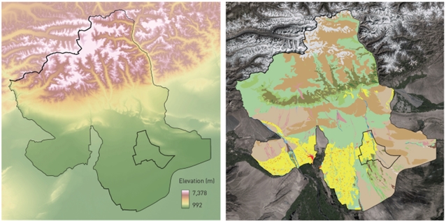
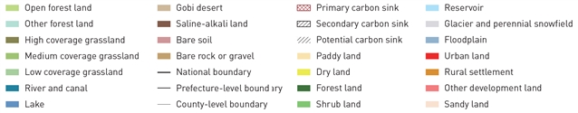
研究区域高程与土地利用现状 © 张謦文,杨颖,袁艺,韩静怡,李迪华
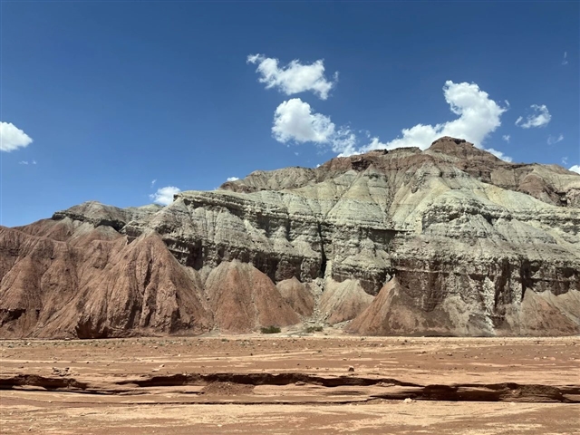
温宿县戈壁风景 © 韩静怡
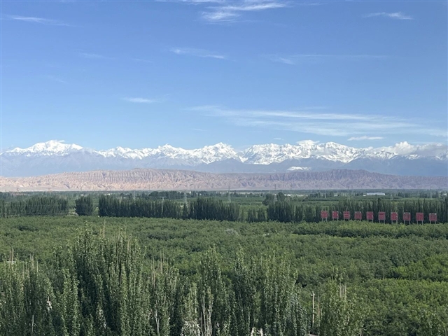
温宿县林草风光 © 韩静怡
数据来源与预处理
在对数据的更新时间、可获取性、时空同步情况,以及不同年份的数据质量进行综合考虑后,选用2015年多源数据展开研究。将所用数据在ArcGIS10.3中统一投影为1980西安坐标系,并转化为1km精度的栅格。

03
研究方法
研究框架
研究按照“碳汇现状评价-空间格局识别-修复策略拟定”的框架展开:首先,对温宿县碳汇的现状(碳吸收、碳储量)和重要性进行评估;其次,识别温宿县碳汇空间格局;最终在前期分析的指导下,通过总结现有研究中的固碳增汇管理措施,针对温宿县土地利用现状拟定生态修复策略。
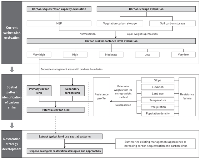
研究框架 © 张謦文,杨颖,袁艺,韩静怡,李迪华
碳汇现状评价
温宿县碳吸收能力通过NEP进行度量,取值为净初级生产力(NPP)与土壤微生物呼吸碳排放(RH)的差值。因温宿县土壤碳酸盐含量较高,因而在进行碳储量评价时应对土壤与植被进行综合考量。土壤碳储量由表土无机碳含量、表土有机碳含量、底土无机碳含量、底土有机碳含量构成。研究结合现有研究与场地地理位置、海拔高度、气候特征等场地情况确定植被碳密度,并计算温宿县植被碳储量。
植被碳储量空间分布 © 张謦文,杨颖,袁艺,韩静怡,李迪华
研究采用等权重方式对二者的指标进行叠加。首先,分别对NEP、植被碳密度、土壤碳密度计算进行极差标准化,然后进行叠加,得到碳汇重要性的评价结果,并采用自然断点法分为“极高”、“高”、“中”、“低”和“极低”5个等级。
碳汇空间格局
参考景观生态学中的空间格局相关概念,本研究将温宿县碳汇空间识别为碳汇腹地、碳汇重要区与碳汇潜力带三大空间类型。
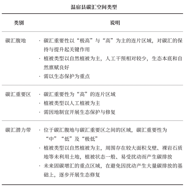
在碳汇重要性评价的基础上,提取评级为“极高”与“高”的区域,以土地利用的边界作为管控的边界,识别碳汇腹地与重要区。
研究提出通过“有潜力”和“有需求”的原则识别碳汇潜力带,用以连接碳汇腹地与重要区。其中,“有潜力”指能以较低的成本进行生态修复、提高碳汇;“有需求”指易产生碳排放、需考虑就地消纳。根据上述原则选取相应的阻力因子(坡度、高程、土地利用、年积温、年平均降水量和人口密度),采用最小累积阻力模型计算,以碳汇腹地与碳汇重要区作为源地,将低阻力区域识别为碳汇潜力带。
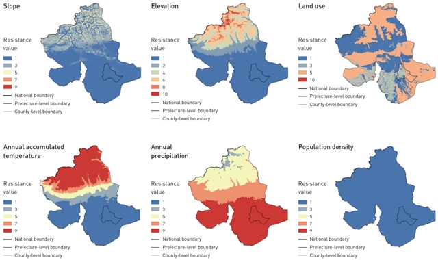
研究区域阻力因子赋值 © 张謦文,杨颖,袁艺,韩静怡,李迪华
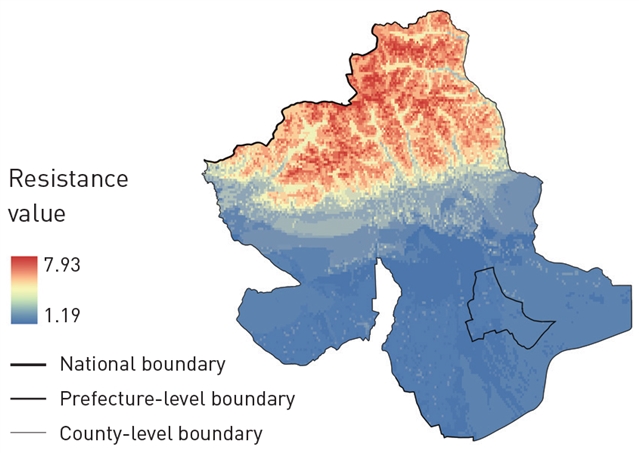
研究区域综合阻力面 © 张謦文,杨颖,袁艺,韩静怡,李迪华
生态修复策略拟定
对碳汇腹地、重要区与潜力带的土地利用现状进行分析,提炼土地利用的典型空间模型。参考已有研究,针对不同土地利用空间模型拟定生态修复策略与管理措施,以期实现维持林地碳汇、适当提升未利用土地碳汇、显著提升耕地与草地碳汇的目标。
04
研究结果与分析
温宿县碳汇现状
碳吸收能力现状
结果显示,温宿县不同区域间NEP值相差较大,碳吸收能力的高低整体呈错落分布。NEP低值区域主要位于温宿县南部戈壁和裸岩石质地区域,其碳吸收能力最弱;同时,常年积雪覆盖、植被稀少的北部天山高海拔区域碳吸收能力也较弱。NEP高值区域主要位于天山南麓海拔2000~3000m的带状区域,该区域自然林地与草地生长状态良好,碳吸收能力最强;同时,南部以农田为主的人工植被区域也具有较强的碳吸收能力。
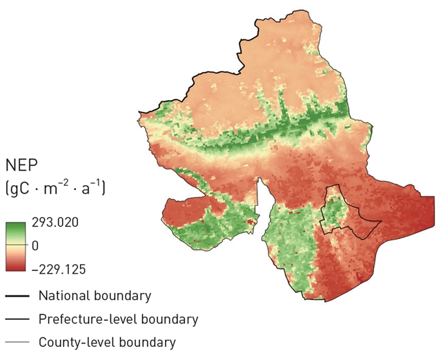
NEP空间分布 © 张謦文,杨颖,袁艺,韩静怡,李迪华
碳储量现状
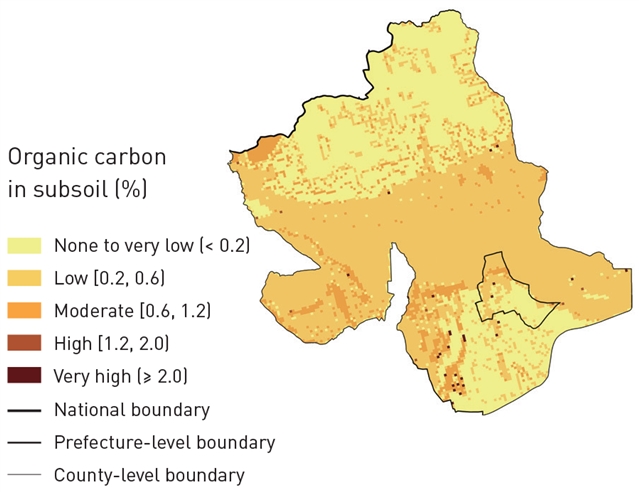
在土壤碳储量方面,温宿县中部土壤总碳储量最高,南部次之,北部最低。其中,县域中部和南部部分区域、东南部冲积平原的表土与底土无机碳含量均较高;天山南麓海拔2000~3000m区域的表土有机碳含量相对较高;而底土有机碳则整体较低,仅在县域中部海拔1500~2000m的区域及南部平原的少量区域有着较高的底土有机碳含量。
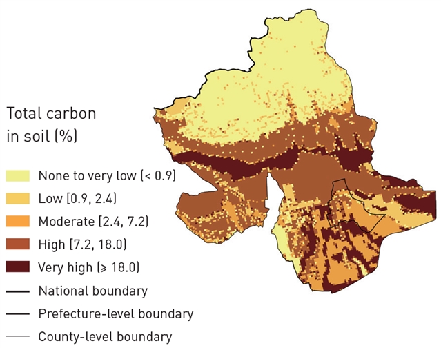
土壤总碳储量空间分布图 © 张謦文,杨颖,袁艺,韩静怡,李迪华

表土无机碳空间分布图 © 张謦文,杨颖,袁艺,韩静怡,李迪华
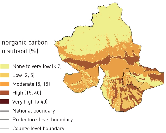
底土无机碳空间分布图 © 张謦文,杨颖,袁艺,韩静怡,李迪华
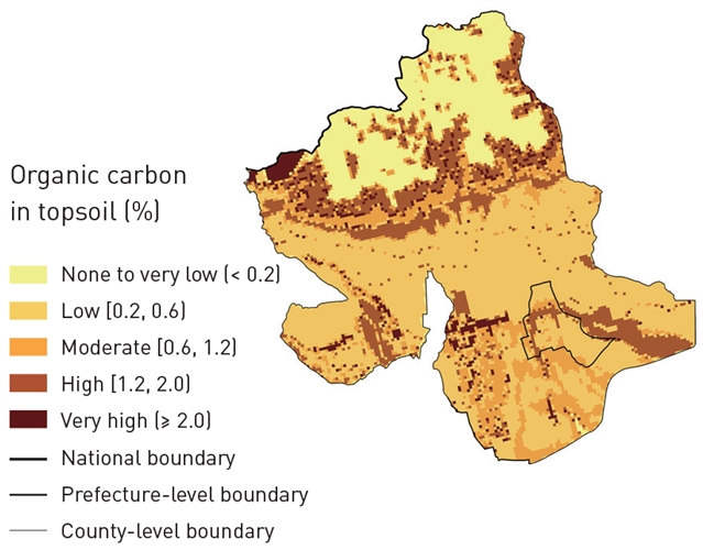
表土有机碳空间分布图 © 张謦文,杨颖,袁艺,韩静怡,李迪华
底土有机碳空间分布图 © 张謦文,杨颖,袁艺,韩静怡,李迪华
温宿县植被碳储量总值为361.013×10⁴t。其中,温带禾草、杂类草盐生草甸碳储量最高,共计89.059×10⁴t;以两年三熟或一年两熟旱作和落叶果树园为代表的栽培植被次之,碳储量为65.322×10⁴t;寒温带和温带山地针叶林虽然面积较小,但其碳密度值最大,碳储量也相对较高,为57.007×10⁴t;温带草原化灌木荒漠由于面积极少且碳密度值较低,其碳储量最少,仅为0.8×10⁴t。
综合植被碳储量和土壤碳储量情况可知,温宿县现有碳储量最丰富的区域主要为县域南部平原与天山南麓,其现状土地利用以林地、草地、耕地为主。在后续生态修复过程中,应重点关注其土地开发和流转情况,保证其碳储量不被大面积扰动。
碳汇重要性空间分布
碳汇重要性评价结果显示,温宿县不同地理环境的碳汇重要性差异较大。其中,天山南麓海拔2000~3000m的区域碳汇重要性最高,评级结果以“极高”和“高”为主;南部和东南部平原的连片农田区域具有较高的碳汇重要性,评级结果以“高”和“中”为主;而在北部天山海拔3000m以上的区域、县域中部和东南部的戈壁与裸岩石质地区域,碳汇重要性评级结果都以“极低”为主,其中穿插有少量“低”值区。
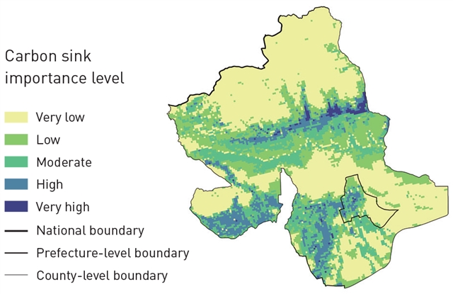
碳汇重要性水平空间分布 © 张謦文,杨颖,袁艺,韩静怡,李迪华
碳汇空间格局识别结果
研究识别得到温宿县碳汇腹地一处、碳汇重要区两处,以及总面积达2259.81km2的碳汇潜力带。其中,碳汇腹地位于温宿县北部海拔2000~4000m的天山南麓区域,面积为1083.87km2;两处碳汇重要区分别位于温宿县南部与西南部的平原区域,总面积为1899.69km2;碳汇潜力带主要位于县域中部。碳汇腹地的土地利用类型以高、中、低覆盖度草地为主,面积占比分别为48.60%、11.48%和31.76%;碳汇重要区的土地利用类型以旱地为主,面积占比高达86.63%;碳汇潜力带土地利用类型以低覆盖度草地与未利用裸岩石质地为主,面积占比分别为51.28%和24.81%。
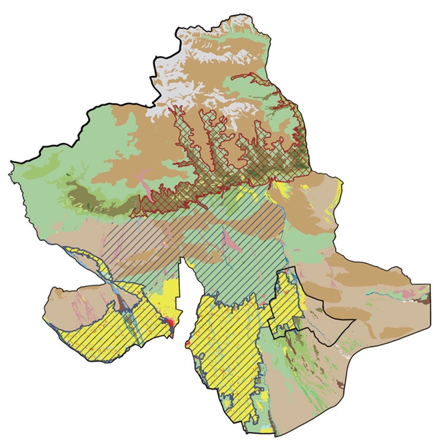

碳汇空间格局识别结果 © 张謦文,杨颖,袁艺,韩静怡,李迪华
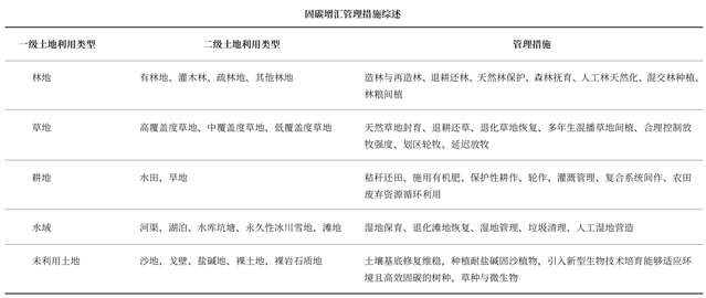
生态修复策略
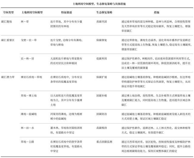
基于温宿县土地利用现状组合类型,团队提炼得到八种土地利用典型空间模型。研究团队以碳增汇为导向提出了相应的生态修复策略,即高碳巩固,戈壁保碳、低碳利用,保碳扩展、固碳补植、固碳防治、高碳维持、重点固碳监测;并因地制宜地拟定生态修复和碳汇效应提升措施。

生态修复策略 © 张謦文,杨颖,袁艺,韩静怡,李迪华
05
结论与讨论
研究基于多源数据评估了温宿县碳汇现状,识别了县域碳汇空间格局,并提出了以碳增汇为导向的国土空间生态修复规划策略。研究结果表明,草地与农田或可成为中国西北干旱区固碳增汇重点关注的土地利用类型。就本案例而言,干旱少雨的气候导致林地在温宿县面积占比较小、可以提供的碳汇效应有限,而草地与旱地则表现出较高的碳汇重要性,是温宿县碳汇的主要来源。现有中国西北干旱区植被碳汇评估的相关研究也指出,温带草原与高质量农田具有较大的碳汇量。在开展中国西北干旱区生态修复时,应充分尊重本土植被的特点,避免在植被类型转换及维系非原生植被生长过程中因物料、能源等投入带来的碳排放;并在保证大面积草地不被扰动的基础上,改善草地管理措施,增加土壤的有机质含量,从而提高碳储量。在农田的碳汇提升上,可通过改变耕作制度、控制农资投入等减少土壤扰动的农作方式,以及优化人工管理措施的方法,进一步提高农田固碳增汇的能力。
温宿县碳汇空间格局的识别结果也对中国西北干旱区的碳汇管理具有一定的借鉴意义。但温宿县的碳汇空间格局表明,除天山南麓的自然区域外,南部人类活动强度较高的农村居民点及农田区域仍然可以产生明显的碳汇效应。这再次凸显了经人为干预的景观对干旱区固碳增汇的重要性,未来研究可进一步细化干旱区人工栽培植被的碳汇评估,从而为人为管理固碳增汇措施的细化提供参考。
本研究则从空间视角出发,通过具体案例,将碳汇现状评估、空间格局分析与规划及具体修复策略拟定相结合,提出了一种固碳增汇的空间途径。本研究的技术路线有助于将碳增汇目标与其他生态修复目标相结合,助力山水林田湖草沙的整体保护、系统修复和综合治理的实现。
本研究运用MCR识别碳汇潜力带的方法具有试验性质,在后续研究成果转向实践的过程中,需要进一步加强实地验证。此外,后续研究可进一步补充收集实测数据,完善数据的时间与精度,提高碳汇评估的全面性与准确性;同时,整体统筹碳汇与其他生态问题,将促进国土空间生态修复与综合治理进一步朝碳增汇的方向发展。
参考文献
[1] China Meteorological News. (2021, August 10). Report Made by the Working Group I from IPCC AR6. China Meteorological Administration.
[2] Xinhua News Agency. (2020, September 22). President Xi Jinping’s Remarks at the General Debate of the 75th Session of the United Nations General Assembly. Chinese Government Website.
[3] Xinhua News Agency. (2021, March 15). President Xi Jinping’s Remarks at the ninth meeting of the Central Committee for Financial and Economic Affair. Chinese Government Website.
[4] Lao, B., Zhuo, W., & Zhu, R. (2020). The rebirth of tropical rainforest—Ecological restoration planning for Sanda Mountain of Xishuangbanna, China. Landscape Architecture Frontiers, 8(1), 108–125.
[5] Lu, F., Hu, H., Sun, W., Zhu, J., Liu, G., Zhou, W., Zhang, Q., Shi, P., Liu, X., Wu, X., Zhang, L., Wei, X., Dai, L., Zhang, K., Sun, Y., Xue, S., Zhang, W., Xiong, D., Deng, L., Liu, B., Zhou, L., Zhang, C., Zheng, X., Cao, J., Huang, Y., He, N., Zhou, G., Bai, Y., Xie, Z., Tang, Z., Wu, B., Fang, J., Liu, G., & Yu, G. (2018). Effects of national ecological restoration projects on carbon sequestration in China from 2001 to 2010. PNAS, 115(16), 4039–4044.
[6] Hou, R., Xia, C., Chen, J., Zheng, Q., Li, H., Huang, J., Huang, X., Deng, J., Han, X., An, T., Hao, Y., & Gou, L. (2022). Carbon storage and carbon sink of forest land and other biomass in the Yangtze River Economic Belt. Acta Ecologica Sinica, 42(23), 9483–9498.
[7] Xie, L., Bai, Z., Yang, B., Chen, M., Fu, S., & Mao, Y. (2023). Carbon sequestration assessment methods at home and abroad for terrestrial ecosystems: Research progress in achieving carbon neutrality. Earth Science Frontiers, 30(2), 447–462.
[8] Lin, Z., Wang, P., Liu, Q., & Yang, Y. (2022). Spatio-temporal evolution characteristics of cultivated land carbon storage and identification of carbon sink areas in Huaihai Economic Zone from 2005 to 2020. Transactions of the Chinese Society of Agricultural Engineering, 38(19), 259–268.
[9] Han, Y., Zhang, S., & Yin, L. (2019). Quantifying the carbon storage capacity and its spatial distribution patterns of green spaces in a metropolitan area: A case study of Seoul, South Korea. Landscape Architecture Frontiers, 7(2), 55–65.
[10] Zhang, H., Peng, Q., Wang, R., Qiang, W., & Zhang, J. (2020). Spatiotemporal patterns and factors influencing county carbon sinks in China. Acta Ecologica Sinica, 40(24), 8988–8998.
[11] Zhang, H., He, J., Yang, X., & Peng, Q. (2022). Zoning and governance of county ecological space for the increase of carbon sinks: A case study of the Beijing-Tianjin-Hebei region. Planners, 38(1), 32–40.
[12] Jiang, J., Xu, J., Wu, W., Zhou, L., & Sun, D. (2014). Patterns and dynamics of China’s human-nature carbon source-sink system. Journal of Natural Resources, 29(5), 757–768.
[13] Fan, Y., & Wei, F. (2022). Contributions of natural carbon sink capacity and carbon neutrality in the context of net-zero carbon cities: A case study of Hangzhou. Sustainability, 14(5), 2680.
[14] Kong, F., Ying, L., Wen, W., & Liang, M. (2021). Exploring carbon sequestration and sink enhancement based on ecological restoration of territorial space. Natural Resource Economics of China, 34(12), 70–76.
[15] Li, M., & Wu, C. (2022). Application of NbS in terrestrial ecological restoration project to promote carbon sequestration and sink in China. Natural Protected Areas, 2(4), 25–31.
[16] Piao, S., Yue, C., Ding, J., & Guo, Z.(2022). Perspectives on the role of terrestrial ecosystems in the ‘carbon neutrality’ strategy. Science China Earth Sciences, 65(6), 1178–1186.
[17] Zhao, J., Liu, Y., & Han, F. (2023). Thoughts on the path of increasing carbon sink in grassland under carbon peak and carbon neutrality targets. Acta Agrestia Sinica.
[18] Zhou, Q., Wang, Q., Zheng, Z., & Liu, W. (2023). Carbon neutrality and ecological remediation in agricultural grain production. Journal of Agro-Environment Science, 42(1), 1–10.
[19] Li, W., Li, J., Zhang, Y., Li, P., & Han, J. (2022). Ecological restoration technologies for lake wetlands for carbon peaking and neutrality. Journal of Nanjing Forestry University (Natural Sciences Edition), 46(6), 157–166.
[20] Yang, L. (2016). Evaluations of carbon sink benefit under the ecological restoration model of Karst rocky desertification [Master’s thesis]. Guizhou Normal University.
[21] Kang, B., Li, M., & Li, H. (2021). A case study of Nature-based Solutions in coastal zone blue carbon ecosystems restoration. Landscape Design, (4), 10–15.
[22] Zhang, X., Wei, W., Zhou, L., Guo, Z., Li, Z., Zhang, J., & Jie, B. (2021). Analysis on spatio-temporal evolution of ecological vulnerability in arid areas of northwest China. Acta Ecologica Sinica, 41(12), 4707–4719.
[23] Lu, Y., Zhao, Y., & Dong, J. (2022). Ecological security evaluation and driving force analysis of three-dimensional ecological footprint in northwestern China. Acta Ecologica Sinica, 42(4), 1354–1367.
[24] Pan, J., & Wen, Y. (2015). Estimation and spatial-temporal characteristics of carbon sink in the arid region of northwest China. Acta Ecologica Sinica, 35(23), 7718–7728.
[25] Pei, Z., Zhou, C., Ouyang, H., & Yang, W. (2010). A carbon budget of alpine steppe area in the Tibetan Plateau. Geographical Research, 29(1), 102–110.
[26] Wang, Y., Luo, G., Wang, Y., Han, Q., Fan, B., & Chen, Y. (2014). Vegetation and soil carbon density in arid region of Central Asia. Arid Land Geography, 37(2), 239–249.
[27] Lai, L. (2010). Carbon emission effect of land use in China [Master’s thesis]. Nanjing University.
[28] Yang, M., Yang, X., Zhao, Y., Huang, Q., Li, C., Cao, W., Chen, A., Gu, Q., Li, Z., & Wang, S. (2023). Estimated carbon storage and influencing factors of alpine grassland in the source region of the Yellow River. Acta Ecologica Sinica, 43(9), 3546–3557.
[29] Wang, S., Zhou, C., & Luo, C. (1999). Studying carbon storage spatial distribution of terrestrial natural vegetation in China. Progress in Geography, 18(3), 238–244.
[30] Sun, X., & Liu, H. (2010). Effects of land use change on wetland landscape connectivity and optimization assessment of connectivity—A case study of wetlands in the coastal zone of Yancheng, Jiangsu. Journal of Natural Resources, 25(6), 892–903.
[31] Fu, F., Liu, Z., & Liu, H. (2021). Identifying key areas of ecosystem restoration for territorial space based on ecological security pattern: A case study in Hezhou City. Acta Ecologica Sinica, 41(9), 3406–3414.
[32] He, B., Ding, J., Li, H., Liu, B., & Chen, W. (2018). Spatiotemporal variation of vegetation phenology in Xinjiang from 2001 to 2016. Acta Ecologica Sinica, 38(6), 2139–2155.
[33] Xiong, Q., He, Y., Li, T., & Yu, L. (2019). Spatiotemporal patterns of vegetation coverage and response to climatic and topographic factors in growth season in southwest China. Research of Soil and Water Conservation, 26(6), 259–266.
[34] He, Y., Kong, Z., Hu, X., Zhang, J., Wang, M., Peng, C., & Zhu, Q. (2022). Water and heat conditions separately controlled inter-annual variation and growth trend of NDVI in the temperate grasslands in China. Acta Ecologica Sinica, 42(2), 766–777.
[35] Jiao, S., Liu, Y., Han, Z., Zhou, K., Hu, L., & Liu, T. (2021). Determining priority areas for land ecological restoration based on ecological network-human disturbance: A case study of Changsha-Zhuzhou-Xiangtan Urban Agglomeration. Journal of Natural Resources, 36(9), 2294–2307.
[36] Shao, R., Wang, W., Shi, K., & Liu, Y. (2014). Research for restoration of soil and vegetation in human disturbance zone of road in high-cold grassland area. Research of Soil and Water Conservation, 21(6), 181–186, 192.
[37] Wang, J., & Zhang, J. (2001). Comparing several methods of assuring weight vector in synthetical evaluation. Journal of Hebei University of Technology, 30(2), 52–57.
[38] Tao, X., Zhang, R., Xu, H., & Zhu, J. (2006). Assessment of City’s sustainable development based on improved entropy method. Journal of Arid Land Resources and Environment, 20(5), 38–41.
[39] Yu, K. (1999). Landscape ecological security patterns in biological conservation. Acta Ecologica Sinica, 19(1), 8–15.
[40] Yu, G., Zhu, J., Xu, L., & He, N. (2022). Technological approaches to enhance ecosystem carbon sink in China: Nature-based Solutions. Bulletin of the Chinese Academy of Sciences, 37(4), 490–501.
[41] Qin, G., & Tian, M. (2022). The development opportunities and implementation path of forestry carbon sequestration under the target of carbon peak and carbon neutrality. Administrative Reform, (1), 45–54.
[42] Wang, C., Wang, R., & Lin, Z. (2010). Carbon sequestration estimation by different tree species and reforestation types in forest ecosystem. Ecology and Environmental Sciences, 19(10), 2501–2505.
[43] Zhang, Y., Yang, G., Liu, N., Chang, S., & Wang, X. (2013). Review of grassland management practices for carbon sequestration. Acta Prataculturae Sinica, 22(2), 290–299.
[44] Xue, C., Li, Y., Hu, C., & Yao, S. (2022). Study on spatio-temporal pattern of conservation tillage on net carbon sink in China. Journal of Natural Resources, 37(5), 1164–1182.
[45] Zheng, J., Cheng, K., Pan, G., Smith, P., Li, L., Zhang, X., Zheng, J., Han, X., & Du, Y. (2011). Perspectives on studies on soil carbon stocks and the carbon sequestration potential of China. Chinese Science Bulletin, 56(26), 2162–2173.
[46] Huo, H., Zhang, J., Ma, A., & Huo, J. (2018). Progress and prospects of soil carbon cycle in arid deserts. Journal of Northwest Forestry University, 33(1), 98–104.
[47] Li, Z., Shan, N., Wang, Q., Li, W., Wang, Z., Bao, S., Dou, H., Ao, W., Pang, B., & Wang, W. (2022). Estimation of vegetation carbon source/sink and analysis of its influencing factors in Hulun Lake Basin from 2013 to 2020. Journal of Ecology and Rural Environment, 38(11), 1437–1446.
[48] Qu, F., Lu, N., & Feng, S. (2022). Effects of land use change on carbon emissions. China Population, Resources and Environment, 21(10), 76–83.
[49] Li, Y., Hao, X., Zhang, J., Fan, X., & Zhao, Z. (2022). Spatial and temporal variation of net carbon sink function of farmland in Aksu oasis in the past 17 years. Arid Zone Research, 39(4), 1303–1311.
[50] Li, M., Liu, S., Sun, Y., & Liu, Y. (2021). Agriculture and animal husbandry increased carbon footprint on the Qinghai-Tibet Plateau during past three decades. Journal of Cleaner Production, (278), 123963.
[51] Wu, Y., Zhang, M., Yang, M., & Jun, Y. (2022). Exploration of the implementation of carbon neutralization in the field of natural resources under the background of sustainable development—An overview. International Journal of Environmental Research and Public Health, 19(21), 14109.
[52] Xu, Q., Dong, Y., & Yang, R. (2018). Influence of the geographic proximity of city features on the spatial variation of urban carbon sinks: A case study on the Pearl River Delta. Environmental Pollution, 243(A), 354–363.
[53] Cao, Y., Wang, J., & Li, G. (2019). Ecological restoration for territorial space: Basic concepts and foundations. China Land Science, 33(7), 1–10.
[54] Han, Y., Zhang, Q., Zhang, S., & Yin, L. (2021). Optimizing the habitat quality of the East Lake Scenic Area in Wuhan. Chinese Landscape Architecture, 37(9), 95–100.
[55] Xu, S., Wang, H., & Kong, W. (2021). Study on mountainous optimization of ecological security pattern based on MCR model from the perspective of disaster prevention: A case study of Beijing-Tianjin-Hebei mountainous area. Journal of Catastrophology, 36(2), 118–123.
本文引用格式 / PLEASE CITE THIS ARTICLE AS
Zhang, Q., Yang, Y., Yuan, Y., Han, J., & Li, D. (2024). Research on the territorial ecological restoration of counties for the increase of carbon sinks—A case study of Wensu County, Xinjiang Uygur Autonomous Region, China. Landscape Architecture Frontiers, 12(3), 10–26. https://doi.org/10.15302/J-LAF-0-020017
阅读原文请点击“Research on the Territorial Ecological Restoration of Counties for the Increase of Carbon Sinks—A Case Study of Wensu County, Xinjiang Uygur Autonomous Region, China”
《前沿》系列英文学术期刊
由教育部主管、高等教育出版社主办的《前沿》(Frontiers)系列英文学术期刊,于2006年正式创刊,以网络版和印刷版向全球发行。系列期刊包括基础科学、生命科学、工程技术和人文社会科学四个主题,是我国覆盖学科最广泛的英文学术期刊群,其中12种被SCI收录,其他也被A&HCI、Ei、MEDLINE或相应学科国际权威检索系统收录,具有一定的国际学术影响力。系列期刊采用在线优先出版方式,保证文章以最快速度发表。
中国学术前沿期刊网
http://journal.hep.com.cn
特别声明:本文转载仅仅是出于传播信息的需要,并不意味着代表本网站观点或证实其内容的真实性;如其他媒体、网站或个人从本网站转载使用,须保留本网站注明的“来源”,并自负版权等法律责任;作者如果不希望被转载或者联系转载稿费等事宜,请与我们接洽。